Theme: Land deeds, Good deeds
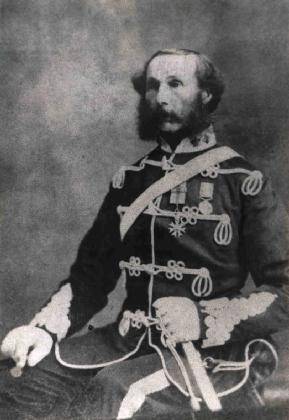 Colonel Harry Childeroy COMPTON
 My 4G Grandfather, who I previously wrote about in "If I Could Meet My Ancestor: Harry Childeroy COMPTON (1759-1839)”, owned a lot of land. I’m not talking about his family’s land in Amport, Hampshire in England, but rather about his colonial property in the newly named Prince Edward Island, Canada. Harry emigrated there in 1803, after serving in Ireland with the British Army (Perth Highland Regiment of Fencible Infantry) during the Irish rebellion in the late 1790s. He was thereafter granted a sizable chunk of property in Prince County, but little if any remains in family hands. So what became of it all?
There are a number of local histories that acknowledge and record some details of Colonel Harry Compton’s proprietorship, his involvement with the Acadian population on his property, his politics and his mixed religious leanings. I also have transcripts of a limited number of conveyances for parts of his land that he later sold. But I'm getting ahead of myself here...
LAND DEEDS
I sure wish I had a copy of Harry's original land deed or grant, as anecdotal sources vary on the boundaries and size of his holdings and the exact circumstance and conditions of his ownership. According to one researcher: "Harry seems to have been given 20,000 acres of perhaps not very wonderful land on PEI, some on Lot 17 and some on [Lot] 20 [which aren't adjacent]. He did a deal with one Townsend who also had his land thus, so that they each had a lot of their own." Others say that the south side of Lot 17 (where Summerside is now) was granted to the Loyalist Daniel Green in 1795 from Governor Fanning. But all seem to agree that Harry owned at least the northern part of Lot 17 on Richmond Bay where he built a house call "The Pavilion". He was later considered the "proprietor" of the whole of lot 17 even though others had title to parts of it.
To understand the historical context and the significance of these terms and locations, a bit of background might help explain the quite complicated and unique land issues in colonial PEI. Before the British seized control of the “Ile Saint Jean” from the French in 1758 (made official in 1763 with the signing of the Treaty of Paris), as many as 4700 French Acadians had settled on this island on the east coast of Canada. Most were evicted back to France, but some stayed on the island or fled to New Brunswick or Quebec. Some later returned.
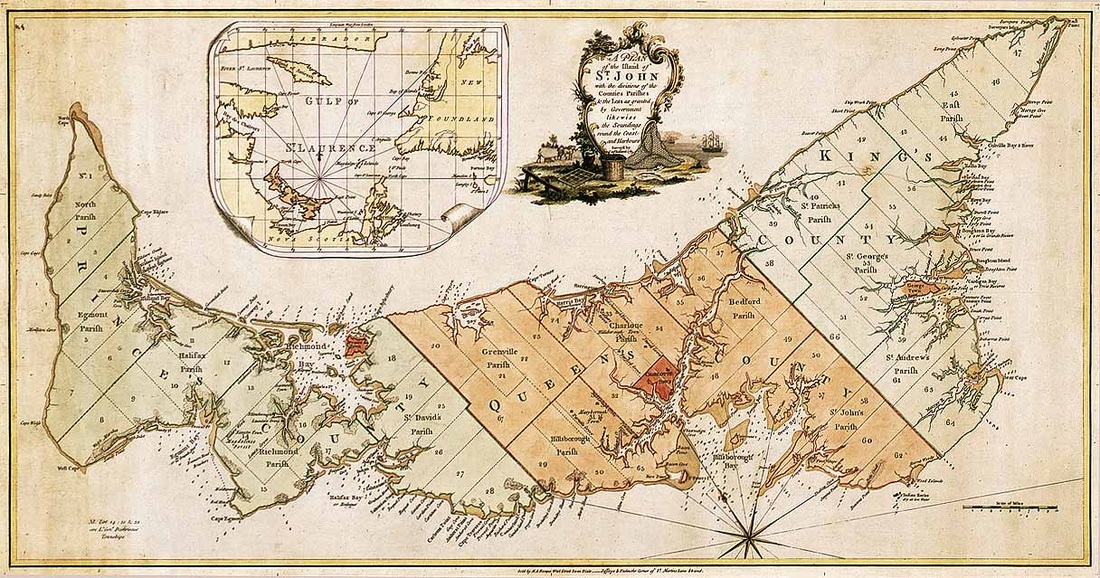
Holland's lot map following his survey of PEI in the 1760s. Harry Compton had land in Lot 17 on Richmond Bay (the narowest part of the island).
In the 1760s “St John Island" was surveyed by a Samuel Holland, which divided into 3 counties (Prince, Queen, and King) and approx 67 lots (like townships), each of approximately 20,000 acres. These lots were then "disbursed by the Board of Trade and Plantations in a land lottery in 1767 to a variety of British politicians and military men. ... These proprietors were tasked with the job of improving their lots and sponsoring new settlers to the Island.”
Generally speaking, the grants also stipulated that their settlers must be Protestant and equal to 1 for every 200 acres. Proprietors were also required to pay "quit rents" of between 2 and 6 shillings per 100 acres to the British Crown to offset administrative costs. Many remained absentee landlords and ignored these requirements. Over time, population grew and lands changed hands. Some property was reclaimed by the crown for arrears (and subsequently granted to others, often Loyalists), and other lands were sold or leased out by proprietors to those settlers who could afford it. And of course there were also tenant farmers working the land.
Our Harry was not part of the original land lottery in 1767. According to an online source, Lot 17 was originally awarded to "Bingham (Benjamin) Burke, Esq., and Theobald (P.) Burke, Esq. In 1781, one half was sold for arrears of quit rent. By 1783, John and/or Walter Patterson were listed as owners with one fourth granted to Loyalists. By 1800 the remainder was owned by Colonel Compton (who sold 6,000 acres to Acadians in this year)." This may not be totally accurate, as the Burke Chronicles say the sale of 6,000 acres occurred in about 1818. In 1800 Harry was not yet on the island. It's also worth noting that in the 1798 census of heads of households, 30 names are listed for Lot 17; most were French, but notable exceptions included Daniel Green and Benjamin Darby. Ownership status was not listed.
Harry certainly didn't hold onto some of his land for very long, judging by a few early land conveyance documents or transcripts that have survived.
- In "... 1807, 21 Acadian farmers signed leases with Colonel Harry Compton."
- In 1809, William Craswell purchased 408 acres + 243 acres of land from Harry Compton.
- In 1817, James and Charles Craswell (sons of the above William) paid £50 and 30 shillings annual rent for a 99 year lease on the "Churchill" property, described as "Seven Acres a little more or less of Arable dry meadow or clear Land Bounded on the West by Lakes the property of Captain Thomas Compton, on the North by the shore of Richmond Bay on the East by Lands now in the occupation of Mr Benj'n Crossman and on the South by Lands the Property of Mr Wm Craswell".
Moving forward to 1838 when another reckoning of the lots in PEI was taken, Harry Compton is listed as the proprietor of Lot 17, 20,000 acres, with a population of 835, consisting mostly of small freeholders. But by 1838 Harry had sold off a fair part of his property. He had also left the island to reside with his third wife in Normandy France. His son Thomas remained behind with his large family, and was considered to be in charge of Harry's "colonial affairs". Then just before Harry died, "certain deeds were executed by him in 1839 leaving land to each of his grandsons, Harry Alfred and John Newman Compton". So this claim of proprietorship of the entire Lot 17 seems a trifle exaggerated! Harry died in 1839 in Normandy, without returning to PEI.
In 1863, the proprietors of Lot 17 were listed as the "Heirs of Col. Compton", but was this official? After confederation in 1867 and then PEI joining Canada in 1873, it is said that all outstanding proprietor-owned land was sold back to the provincial government, although not without a lot of legal hassle! I do not know if Harry's heirs were affected by this legislation.
In 1863, the proprietors of Lot 17 were listed as the "Heirs of Col. Compton", but was this official? After confederation in 1867 and then PEI joining Canada in 1873, it is said that all outstanding proprietor-owned land was sold back to the provincial government, although not without a lot of legal hassle! I do not know if Harry's heirs were affected by this legislation.
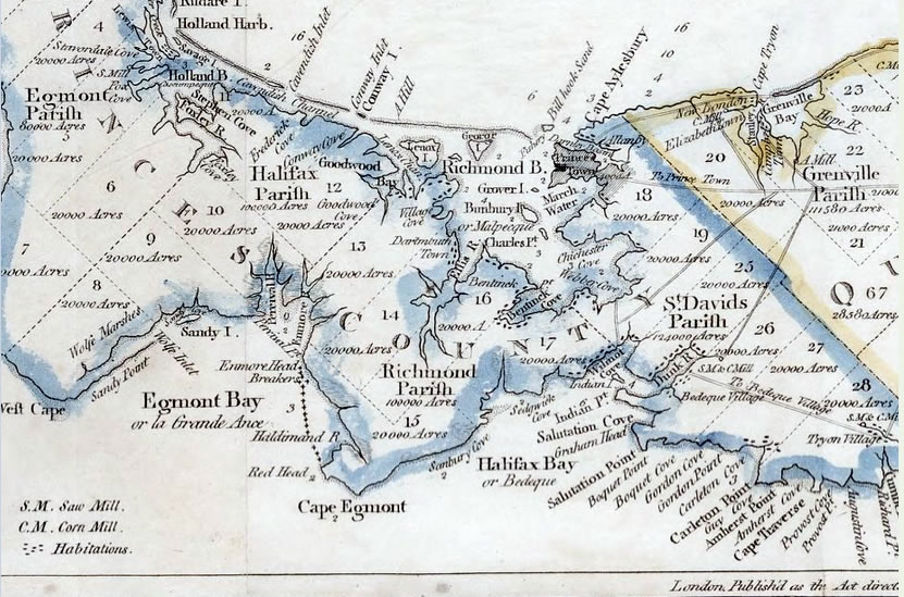 1798 Ashby map of Prince County showing Malpeque/Richmond Bay
 GOOD DEEDS
So what was Harry's good deed? It has to do with an early Acadian Roman Catholic cemetery on his property and a revealing clause in the 1817 lease to the above Craswell brothers.
I am indebted to a very enthusiastic researcher with French roots in PEI and a keen interest in locating this cemetery. He contacted me last year and is credited with unearthing many of these clues in news clippings, conveyances, maps and publications. Here's some further evidence and details ...
Harry seems to have had some sympathy for the Roman Catholic faith (in spite of having been brought up and retaining his allegiance to the Anglican Faith). It is written that his son, daughter and housekeeper all converted to Catholicism. There are also accounts of Harry meeting and having long conversations with a Roman Catholic priest and fellow passenger aboard the "Teresa" on their journey to PEI in 1803, sailing from Portsmouth on August 23 and arriving in PEI on September 23. Once on the island, Harry also made friends with the local Abbe and was known to entertain RC dignitaries in his home. As the French settlers on his land were Roman Catholic, he seemed motivated to support their religious activities.
Long before Harry arrived on PEI, and even before the British gained control of the island in 1758/1763, there was an RC parish called Malpeque (St John Baptist) on the shores of Malpeque Bay (now Richmond Bay, whose extensive shoreline borders on several lots including Lot 17). When Acadians returned to the area, some settled in a new location several miles south of the original village of Malpec [aka Malpeque, aka St Eleanors] in Lot 17. In either 1772 or 1785 they erected a 20 foot long log church dedicated to St John the Baptist between the River Platte and North St Eleanors. Instead of establishing a cemetery near the church, they initially buried their dead on a small island opposite George Inman’s point. In 1794 they opened a cemetery on high ground at a place called Le Vieux Magasin (unfortunately I don't know where this was). In 1796 they built a new framed church twice as long near the cemetery.
In a letter reportedly written by Col Compton (perhaps in 1804) to Mgr Denaut, Bishop of Quebec, he begs that a priest be sent to his Acadian village, and says “I am proprietor of the Township of which the village forms a part and together with numerous family who are Roman Catholic reside in the village. I have, as directed as I understood was your Lordship's wish, attached to the Church six acres of cleared land, the inhabitants have repaired in a good manner the church and tithes they pay are considerable and daily increasing. … I inform your Lordship that I have set apart six acres of land for the church. It is my intention after a little to establish a new village in this township, on a plan so as to place the church exactly in the centre of the village. We shall subscribe liberally towards the building of the Church and forty acres of land shall be attached to the cure for a presbytery.”
Harry sends another letter and petition in 1807 asking again for a resident priest. He adds: “I had almost forgot to say that not only six acres of land, but any reasonable number of acres will be added to the church for the comfort of the priest.”
Then about 1807 or 1808, the Acadians decided of their own accord to move their church themselves about a mile and a half to an open field near Harry's Pavillion residence. It was now nearer the water spring, but now separated from the cemetery and presbytery. Harry was apparently not pleased with these unapproved actions, and ended up not keeping his promise to prepare suitable premises for a resident priest.
In 1812 when a RC delegation arrived for a mission, they found “the miserable chapel, remarkable not only for its smallness, but much more for its total destitution of ornaments and linen. The Bishop goes on to say that the useless displacement of the Church, the uncertain tenure of the land upon which it stood, the want of a presbytery and of a farm for the use of the priest were the reasons which prevented the Bishop from leaving Father Beaubien there as had been originally disposed.”
We learn further details about the early Acadian church and cemetery in Lot 17 from one of several articles written by Harry's descendant Hubert G Compton. It was titled “A Short Sketch of North St. Eleanors", and published in the Charlottetown Guardian 16 Dec 1906:
“The writer in his last omitted mentioning, Robert, the youngest of the Craswell family. He settled on part of the last purchase a little beyond the Post Office. He became a very prosperous farmer and at his death bequeathed this valuable property to his youngest son Harry. This farm did not extend to Richmond Bay, as the burying place of the first settlers in Lot 17 intervened between it and the Bay.
"The ground in use for burials was enclosed by a substantial stone wall and a cross erected in the centre of the enclosure. Father Poirier P.P. of Mischouche had the cross placed there in the year 1840 or about that time. The same priest had the remains taken up and place in Miscouche cemetery many years since, but those who cultivate this field at the present day are strangers to these facts.”
So this would explain what happened to the cemetery and and provides its location near the Craswell property by the shore. According to the Burke Chronicles book, the cemetery was moved to Miscouche in about 1817 or 18. (This book is an excellent source for those wanting additional details - see link below.)
According to a transcription of Harry's Land Conveyance document for the above-mentioned "Churchill" property (which was drawn up 29 Sep 1814 but not registered until 20 Feb 1817 in PEI), conditions included "reserving to the said Harry Compton his Heirs Executors and Administrators the width of six feet together with a Dyke round said Premises to the Burying Ground allowing the French agress and regress for the purpose of Burying their Deas [sic]…"
According to an old plot map, by 1880 this 7 acre plot seems to have been absorbed into the neighboring Craswell property (then belonging to Harry C Creswell) - by then it extended all the way to Malpeque/Richmond Bay.
According to an old plot map, by 1880 this 7 acre plot seems to have been absorbed into the neighboring Craswell property (then belonging to Harry C Creswell) - by then it extended all the way to Malpeque/Richmond Bay.
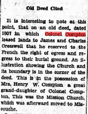 "Old Deed Cited" from The Charlottetown Guardian, 9 Aug 1932
 From the Charlottetown Guardian, 9 Aug 1932, pg 6, (part of a bigger article entitled “Eucharistic Congress First in Island History - St John Baptist Parish, Miscouche, Where Congress Will Be Held is Rich in Historic Association”):
“Old Deed Cited - It is interesting to note at this point, that an old deed, dated 1807 * in which Colonel Compton leased lands to James and Charles Cresswell that he reserved to the French the right of egress and regress to their burial ground. An illustration showing the Church and its boundary is in the corner of the deed. This is in the possession of Mrs. Henry W. Compton a great grand-daughter of Colonel Compton. This was the Mission Church, which was afterward moved to Miscouche.”
* I think this should read 1817 rather than 1807.
In reference to Mrs Henry W Compton, this was Viola Catherine "Kate" - also born a Compton - who married a cousin William Henry Compton. They were my great-great-aunt and uncle. I sure wish I knew what happened to that old deed! The sketch would have been most useful!
My very resourceful friend in Ontario has taken a current picture of the north shore of Richmond Bay near the location of the WWII RCAF station and airport (now Slemon Park complex), and marked the location of the old burying ground. It's got to be at least very close!
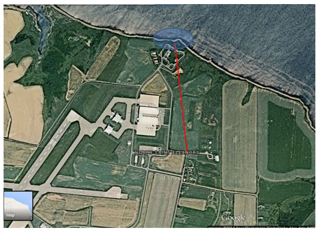
Probable location of the old Acadian burying ground in Lot 17 PEI on the shores of Richmond Bay.
REFERENCES and FURTHER READING
1767 "Proprietors of PEI Lots in 1767-1810"
1807 Acadian Leases and "Pioneer Acadian Entrepreneurs on Prince Edward Island"
1838 PEI Proprietors (as published in the Colonial Herald, 3 Feb 1838 pg 4 col 4)
"A Short History of the Comptons of Chitterne", by C.M.L. Koppana (private publication)
"History and Politics of Prince Edward Island" by Fred Driscoll
Island Newspapers - UPEI Robertson Library digital search
"Past and Present of Prince Edward Island", 1906, published by F.F. Bowen & Col, Charlottetown, pg 85
PEI Historical maps and related history
"Prince Edward Island - How it was Bought Back from the Landlords", by Hugh C. E. Childers, c1895
"The Burke Chronicles - The Story of the Beginnings of the Roman Catholic Parish on Prince Edward Island to 1885", Edited by Ernest MacDonald - see page 99+ (takes a while to download)
"The Origins of the Land Question on Prince Edward Island, 1767-1805” by J.M. Bumsted


 RSS Feed
