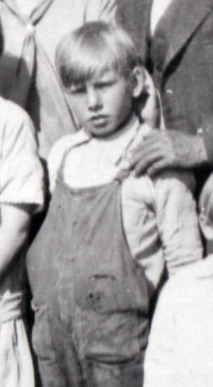
 Claude Angus HENSON as a boy, c1927
 Claude's parents were married in the USA in August 1910, just after the US census that year, where each were listed as single in different households. After starting a family, they emigrated to Canada in about 1914, so missed being recording in the 1911 Canada census. The family fortunately shows up in the 1916 Canada "prairie" census along with their first three young children Pearl, Wayne and Ethel. It was too early for Claude, though. Later census in Canada are not yet accessible by the public, so this was my only opportunity to find Claude in our federal census.
Finding this ancestral family in 1921 records is cause for great celebration, as they had been hiding in the census indexes for some time. It turns out that this was yet another example of hard-to-read handwriting (in part due to the use of a thick black pen), and poor deciphering skills by the indexers. The wrong names were indexed. Unable to guess the actual spelling variant used in the indexes, I turned to the census images on the Library and Archives Canada (LAC) site (whose indexes produced no correct results either using the surname Henson). I checked the notes provided by LAC for known issues with this census. They warned that in some areas, the names had been cut off and not shown in the film images. That did not sound promising.
Knowing that my Hensons lived near Boyle in rural northern Alberta, I then accessed the district and subdistrict lists on the LAC site to determine the best search parameters for that location (thankfully made easier with details provided by the 1916 census). There I learned that the the census images for that area DID exist. Limiting the search to district and subdistrict numbers but no names, the list of results was very long. But I got lucky. On the very first page I recognized the first name Wayne who was the right age to be Claude's older brother. So I accessed that image, and - Voila! - there they all were with names included!
Claude Henson was listed as "Clark Hannas" - really! Of course, the others in this family were also listed as "Hannas". While I admit that Bessie's name is hard to read, I would never have read her name as "Burt". All the other first names were fortunately correct, except for poor Pearl whose name had been corrupted to "Paresh". I spent some time submitting correction notes to LAC. Checking ancestry.com for the name Hannas, I found them there as well with the exact same errors. So I sent them correction notices too.
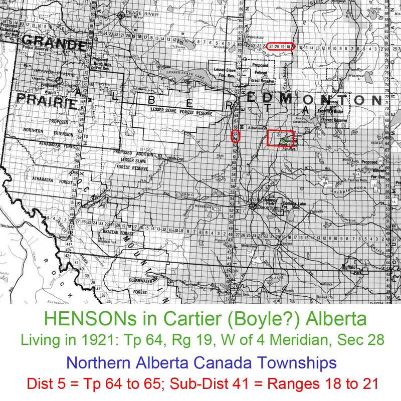
The only mystery remaining here is the location of "Cartier" Alberta, as it doesn't exist on modern maps. Although there is a Cartier Creek Campground in Alberta, it's hundreds of miles to the southwest. Cartier must be in the Boyle area, though, because the district and subdistrict numbers are the same. I checked on the 1929 township map of the western provinces, but even Boyle wasn't shown. So I've marked up a clipping from that map (below) to show the Henson's location in 1921.
I am absolutely thrilled that my young father and his family have finally been found in the 1921 Canada census!
Update regarding "Cartier" and other Alberta locations - 5 Feb 2018:
Thanks to my cousin Sherrill and the information she found on the Province of Alberta Archives site (explaining the development and organizational history in what is now County of Athabasca #12 in Alberta) , I have learned that the Cartier Rural District #637 was created in 1914. It was renamed as Cartier Municipal District in 1917 (where my Henson father was enumerated in 1921), and renumbered as #103 in 1945 (same name). Then in 1947 the Cartier MD was merged with a number of other districts (105, 106, 102, 122, and Athabasca 103) to become a larger Athabasca MD 103. In 1958 it was renamed again when it amalgamated with the Athabasca School Dist #42 to form the "County of Athabasca #12".
For reference: 1 section = 1 square mile, usually divided into quarters for homestead applications. A township is 36 square miles (a square 6 miles by 6 miles). The further north you go, the larger the township number. The further west you go, the larger the range number until you hit the next meridian when the range numbers start again at one.
In the 1921 Canada census, Cartier Municipality is said to encompass townships 64 & 65, range 19. The Henson homestead was in the NE1/4 of S28, Tp64, R19, W4, so was within this municipality. We know they lived near Boyle, a village now within the County of Athabasca. On a larger scale township map of this area, Boyle is shown in NE1/4 of Sec 3, (inferred Tp 65, R 19), which would put Boyle within Cartier Municipality as well. So we're looking at different ways to describe parts of the same area.
Boyle village was named after the Hon J R Boyle, Liberal representative as well as a lawyer and judge. Boyle was part of the Warren School District. School Districts in this area that are mentioned in our Henson family history are:
School Dist #: section-township-range-meridian: date range
• Warren #3265 [Boyle]: 3-65-19-W4: 1915-?
• Flat Creek #3106: NW 28-66-19-W4: 1914-1949
• Cash Creek #3045: 18–64-20-4: 1913- ?
• Plum Lake #2815: 5-65-20-W4: 1912-1948
It would seem to me that the names used for residences must have been rather loosely applied by the people who lived there. Or else the above coordinates did not encompass all of the associated area. In looking at the homestead application by Angus HENSON in the period of 1914-1919 (homestead in NE1/4 of Sec 28, Tp 64, R 19, W4, just south of Boyle), he said he was living in Flat Creek (which is listed as Township 66 in the above list , which would place it a few miles north of Boyle). But perhaps, considering the vast expanse of land in this area, a few miles difference is close enough!
REFERENCES
Library and Archives Canada - Western Canada Land Grants (with link to map...)
Map of Western Canada Townships - data2.collectionscanada.gc.ca/nmc/n0043265.pdf
Library and Archives Canada (LAC) - census pages
Library and Archives Canada (LAC) - 1921 census image and index for Claude Henson
Province of Alberta Archives (PAA) - County of Athabasca #12 - Fond PR2315
Athabasca County, Alberta website - 2016 Athabasca County Land Ownership map


 RSS Feed
