Theme: Taxes
In my recent story about Terry’s ancestor William BOORMAN II who died in 1790, I promised that: “William III’s youngest son Edward became the next BOORMAN wheelwright of Staplehurst [Kent, England], keeping up the tradition of trade if not the first name. However, Edward did not own his property according to tithe records. But that's another story!”
It’s now time to share more details about William's land and his grandson Edward BOORMAN.
About 1837 when England instigated their civil registration programs for births, marriages and deaths, they also initiated a very comprehensive tithe survey of land ownership, occupancy and usage throughout Britain that lasted until the early 1850s. According to online dictionaries, “tithe” means “one tenth of annual produce or earnings, formerly taken as a tax for the support of the church and clergy”. Further clarification is provide by a guide on this Tithe Survey, published by the National Archives, which says in part: -
“By the early 19th century tithe payment in kind seemed a very out-of-date practice, while payment of tithes per se became unpopular, against a background of industrialisation, religious dissent and agricultural depression. The 1836 Tithe Commutation Act required tithes in kind to be converted to more convenient monetary payments called tithe rentcharge. The Tithe Survey was established to find out which areas were subject to tithes, who owned them, how much was payable and to whom.”
I have recently discovered these tithe survey records (both indexes and images of the registers and associated maps) are available on The Genealogist site by subscription - https://www.thegenealogist.co.uk/tithe - although searching the index is free. The Boorman name is listed 1,342 times in the index, although many names if not properties are usually repeated multiple times.
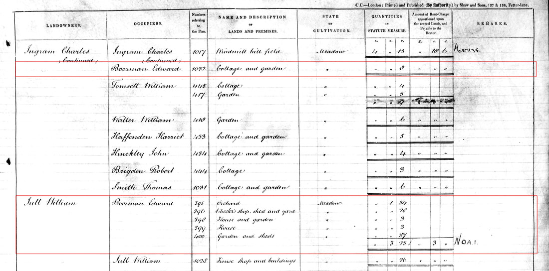
Tithe Apportionments Register, Staplehurst, Kent, England, 1838.
Outlined in red: properties leased by Edward BOORMAN, wheelwright
© TheGenealogist © Crown copyright images reproduced courtesy of The National Archives, London, England
Edward BOORMAN of Staplehurst Kent is listed 6 times as occupier of various plots, all listed on the same page of the Apportionments register [piece 17, sub-piece 343, image 34]. One of the plots he rented [number 1032] was owned by a Charles Ingram:
Lot 397 (on the corner of High Street and Chapel Lane) is not included in Edward’s list because it was the property of the Independent Chapel (also known as The Lower Grove or The Presbyterian Meetinghouse; non-conformist) that had been leased to this church in 1766 by Edward BOORMAN’s grandfather William. According to the Tithe index, Plot 397 was owned in by a large group of men in 1838:
- Plot 1032 a “cottage and garden” and cultivated as a “meadow”
- Plot 395 was an orchard
- Plot 396 a wheeler’s shop, shed and yard
- Plot 398 was a house and garden
- Plot 399 a house
- Plot 400 was a garden and sheds.
Lot 397 (on the corner of High Street and Chapel Lane) is not included in Edward’s list because it was the property of the Independent Chapel (also known as The Lower Grove or The Presbyterian Meetinghouse; non-conformist) that had been leased to this church in 1766 by Edward BOORMAN’s grandfather William. According to the Tithe index, Plot 397 was owned in by a large group of men in 1838:
Landowner John Osborne Junior & Samuel Harman & Samuel Buss & Robert Barling & Richard Booy & William Foster & George Mullinger & Thomas Harnden & Isaac Watson & Joseph Brown & George Archer Junior & Richard Holmes Junior
Occupier Robert Orpin
Parish Staplehurst
County Kent
Original Date 11th August 1838
Plot 397
Reference IR 29/17/343
Tithe Apportionments, 1836-1929 [database online]. TheGenealogist.co.uk 2018
Original data: "IR29 Tithe Commission and successors: Tithe Apportionments" The National Archives
Perhaps the occupier Robert Orpin was the minister? What’s also interesting here is that, in spite of being a church, the owners still had to pay a tithe of 1£ 17s 6d to the Rector (presumable of the official Church of England that stood a short way up the hill on High Street).
I am uncertain about how to accurately read the numerical columns in these registers, partly because of the excessive use of “ditto” marks, even at the top of pages.
If my understanding of this process is correct, payment of these tithes to the Rector would have been the responsibility of the land owner rather than the occupier, but would have likely been passed on to the occupier as part of their rent.
Although not all parishes were included in this survey (excluded if tithes weren’t applicable in that area), these extensive tithe records are a valuable resource for many parts of England in this time period. I’m glad that Staplehurst in Kent was among those parishes surveyed, and that these entries provide insight into the extent of Edward's leased properties and status.
I am uncertain about how to accurately read the numerical columns in these registers, partly because of the excessive use of “ditto” marks, even at the top of pages.
- “Quantities in Statute Measure” [A. R. P. columns: 1 acre = 4 roods, 1 rood = 40 square perches (also called rods or poles), and 1 perch = 16½ feet]]
- “Amount of Rent-Charge apportioned upon the several Lands, and Payable to the Rector” [£ s d columns = English pound, shilling, pence]
If my understanding of this process is correct, payment of these tithes to the Rector would have been the responsibility of the land owner rather than the occupier, but would have likely been passed on to the occupier as part of their rent.
Although not all parishes were included in this survey (excluded if tithes weren’t applicable in that area), these extensive tithe records are a valuable resource for many parts of England in this time period. I’m glad that Staplehurst in Kent was among those parishes surveyed, and that these entries provide insight into the extent of Edward's leased properties and status.
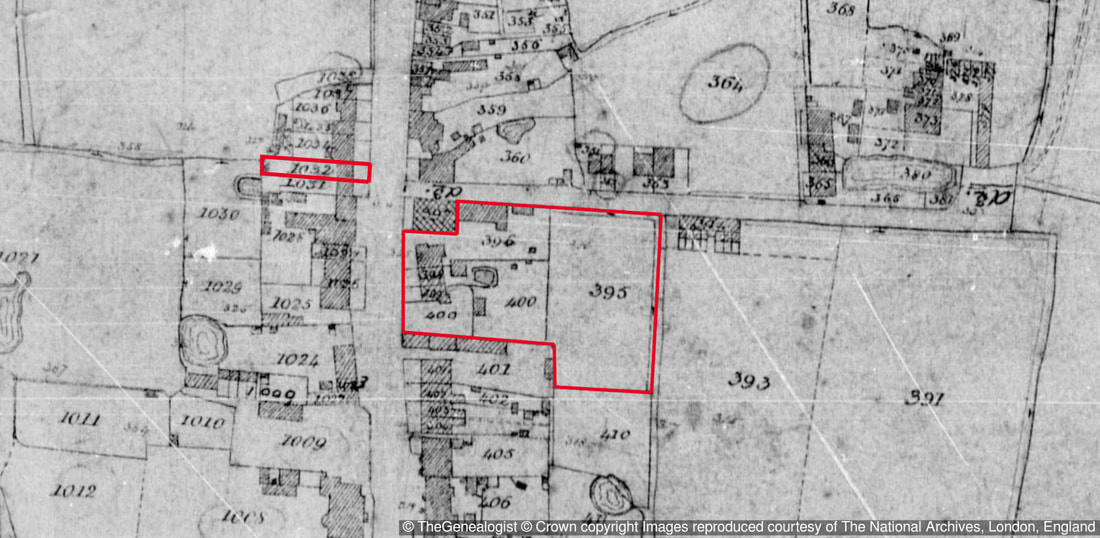
Tithe Survey map, Staplehurst, Kent, England, 1838.
Outlined in red: properties leased by Edward BOORMAN, wheelwright
© TheGenealogist © Crown copyright images reproduced courtesy of The National Archives, London, England
Edward BOORMAN was Terry’s 4-times-great Uncle, the youngest son of William BOORMAN III (1746-1824) and Ann WELLER (1745-1829) and the 9th of their 10 children. His grandfather William Boorman II left extensive property in Staplehurst, Headcorn and Cranbrook (all in Kent) to his grandchildren under the care of his two children William BOORMAN and Mercy CARPENTER. After the death of these children, the properties were then to be sold or otherwise equally divided among the next generation. The information in these tithe documents confirms that Edward was not a landowner, so the Staplehurst properties inherited by his father William must have been sold, with the proceeds split about 8 ways amongst his surviving children, including Edward. Yet it was Edward who continued his father’s wheelwright business there, and probably continued to occupy at least some of these ancestral lands as tenant after his parents’ death in the 1820s, judging by the land description and proximity to the Independent Chapel.
Edward married twice, first to Sarah HUCKSTED in 1808 in Maidstone Kent, and secondly to Harriet TOWN in 1845, 11 years after Sarah’s death. Edward and Sarah had at least seven known children between 1809 and 1823, only one of them a girl. Edward died in Staplehurst on 14 Jun 1858 at the age of 71, and was also buried there. Although listed on his parents’ gravestone, it is not clear if he was buried with them.
They say taxes are inevitable, so I wonder what other types of taxes Edward had to pay during his life? I wouldn't be surprised if the money he inherited from his father and mother's estate was taxable.
REFERENCES and FURTHER READING
England Tithe Survey Research Guide (National Archives) - http://www.nationalarchives.gov.uk/help-with-your-research/research-guides/tithes/
National Archives Catalogue - Staplehurst Tithe Map -
http://discovery.nationalarchives.gov.uk/details/r/C2302460
The Genealogist Tithe Records - https://www.thegenealogist.co.uk/tithe
England Tithe Records (National Institute) -
https://www.familysearch.org/wiki/en/England_Tithe_Records_(National_Institute)
The Tithe Surveys of the Mid.Nineteenth Century By H. C. PRINCE -
http://www.bahs.org.uk/AGHR/ARTICLES/07n1a3.pd

 RSS Feed
